Drainage Design and Analysis Software
Our range of software allows us to undertake many tasks which would be impossible using manual techniques and river modelling is an example of this. At the same time our software speeds up other processes, such as the design of drainage systems for instance. Overall then, our software means that our Clients get a better service delivered more efficiently.
Please Contact Us for further details.
Flood Modeller Pro (formerly ISIS) software
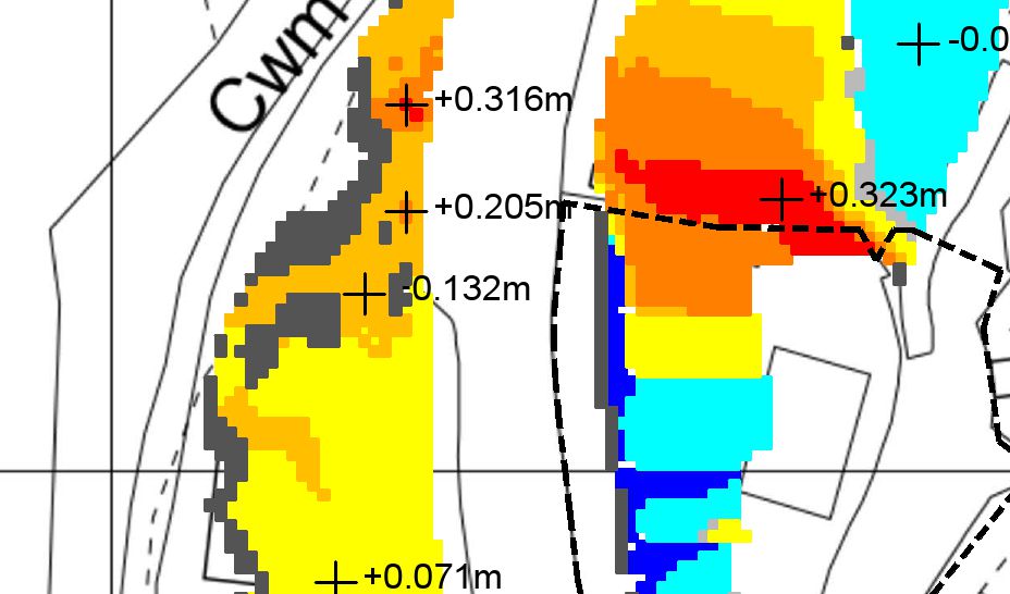
Flood Modeller Pro software combines 1D and 2D flood modelling capabilities so enabling the use of linked 1D - 2D hydraulic river models. These models can be used to represent complex river and flood plain systems and are often used to assess the flood risk to developments proposed to be located close to flood prone areas.
2D flood modelling can be used to assess the consequences of the failure of river or coastal defences or to model the flooding caused by a dam failure. A further use is to represent the flow of water across the ground surface due to flooding from a drainage system manhole.
Flood Modeller Pro is the Environment Agency's 'standard' river modelling software package. By using this software we can make use of the EA's existing river models to investigate in detail the flood risk to proposed developments in England.
TUFLOW software
TUFLOW is a 2D flood modelling program which uses ESTRY 1D modelling software to produce an overall 1D - 2D software package. This then allows the use of linked 1D - 2D river models in a similar way to Flood Modeller Pro.
Linked 1D - 2D river models allow the 1D model to represent the river channel while the 2D model represents the flood plain. The two models operate in conjunction with each other with the 1D model passing flood water to the 2D model and visa versa as the storm develops. This methodology allows each program to do what it does best, to arrive at the most cost effective modelling solution.
Natural Resources Wales' preferred river modelling software package is TUFLOW. By using this program we can therefore utilise their existing river models to investigate the degree of flood risk to proposed developments in Wales.
Micro Drainage software
We use Micro Drainage software primarily for the design of drainage systems to serve new developments. This includes both foul and surface water systems together with SUDS features.
We can also use the software to analyse existing drainage systems.
System 1 and Simulation Modules
The System 1 software is used to design drainage systems to meet the requirements of the 'Sewerage Sector Guidance', 'Sewers for Adoption' or other design specifications such as the DMRB. We can then use the Simulation module to analyse the hydraulic performance of the system under a variety of conditions to confirm that it will actually meet the design requirements in practice.
The Simulation module is also used to analyse the performance of existing drainage systems such as when investigating known flooding problems for example.
Source Control Module
The Source Control module allows us to quickly and efficiently design SUDS features including conventional soakaways, rainwater harvesting systems, attenuation tanks and ponds, infiltration trenches and basins, etc.
Flood Estimation Handbook (FEH)
The FEH is the industry standard method for assessing flood flows in watercourses. It is often the initial stage of many engineering processes, for example, the flows used in hydraulic river modelling are usually produced by an FEH analysis.
The FEH, originally published in 1999, is a development of the Flood Studies Report methodology of 1975. It includes two methods for flood estimation, the Statistical procedure (WINFAP) and the Revitalised Flood Hydrograph (ReFH) rainfall-runoff method. The statistical procedure can produce an estimated peak flow of a given return period at both gauged and ungauged sites. The ReFH method can also be used to estimate peak flows but in addition can also generate design flood hydrographs.
The Environment Agency's 'Flood Estimation Guidelines' is a good source of information on the application of the FEH methodology and is supplemented in Wales by Natural Resources Wales' Guidance Notes.
AutoCAD Civil 3D
AutoCAD Civil 3D software, as well as providing 2D and 3D computer aided drafting, is specially tailored for use in the civil engineering field. We use it primarily as a 3D ground modelling tool, using a topographical survey or LiDAR data to provide the existing ground surface information.
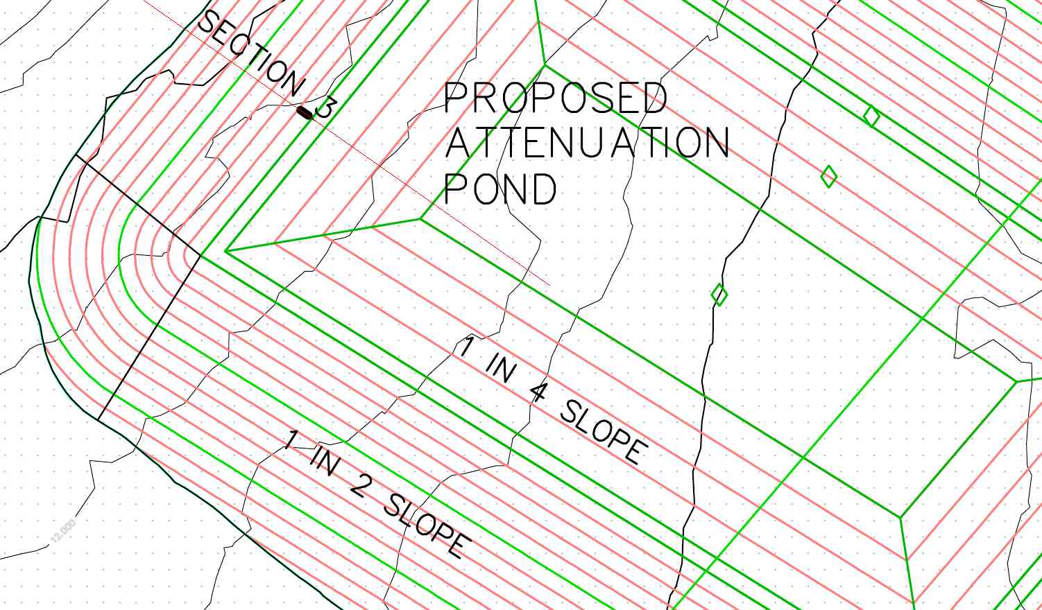
The software is particularly useful in the design of SUDS features such as attenuation ponds, swales and infiltration basins. These often involve quite complex earthwork shapes either excavated into, or constructed above the existing ground surface. The software enables the work to be produced quickly and accurately which results in a cost effective design for our clients. The use of 3D modelling has the added benefit of allowing us to simply produce further information such as cut and fill earthworks quantities.
We also use AutoCAD LT, which is a 2D computer aided drafting tool, for the production of straightforward construction drawings.
Ordnance Survey © Crown copyright 2019.
All rights reserved. Licence number 10005067.